At Future Thota, we specialize in drone surveys for coffee plantations in Coorg, delivering precision-driven agricultural data insights. Compared to traditional methods, drones offer much more accurate land area surveys. Using highly precise GPS systems (such as RTK-enabled drones), we achieve mapping errors as low as a few centimeters.
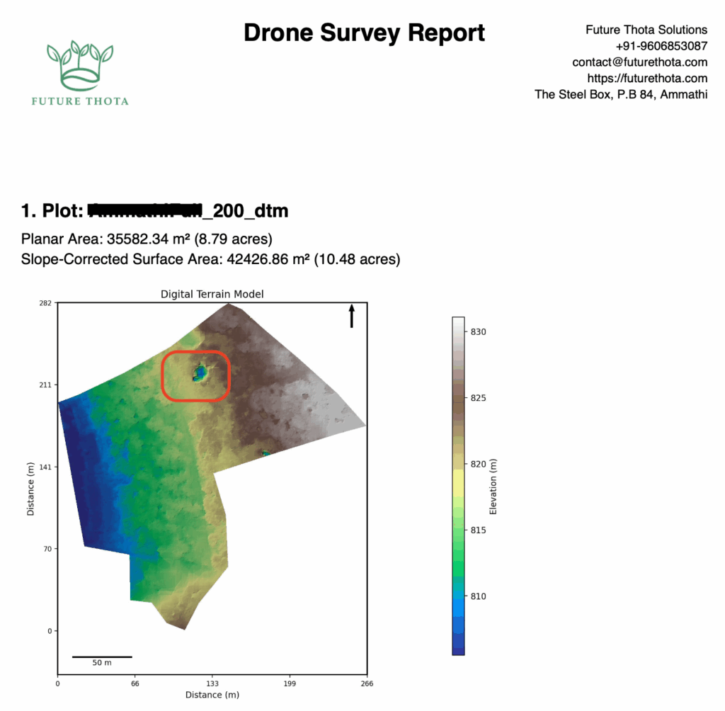
Through drone mapping, we generate Digital Terrain Models (DTM) that represent the bare earth surface, removing trees, vegetation, and buildings. DTMs are critical for understanding land slope variations and calculating accurate surface area measurements — a necessity for plantation management.
In this study, we compare land survey data collected at different drone flying altitudes and recommend best practices for achieving the most accurate results, especially for drone surveys in coffee plantations.
Drone Survey in Coorg – Case Study Overview
This project focused on surveying a coffee plantation in Coorg, located in the Western Ghats of Southern India. We conducted multiple flights over the same property, at different fixed altitudes: 150 ft, 200 ft, and 400 ft.
Key parameters:
Front overlap: 80%
Side overlap: 70%
Fixed grid mission mode
Using this approach, we aimed to study how flight altitude affects DTM quality during a drone survey for plantations.
150 ft altitude
200 ft altitude
400 ft altitude
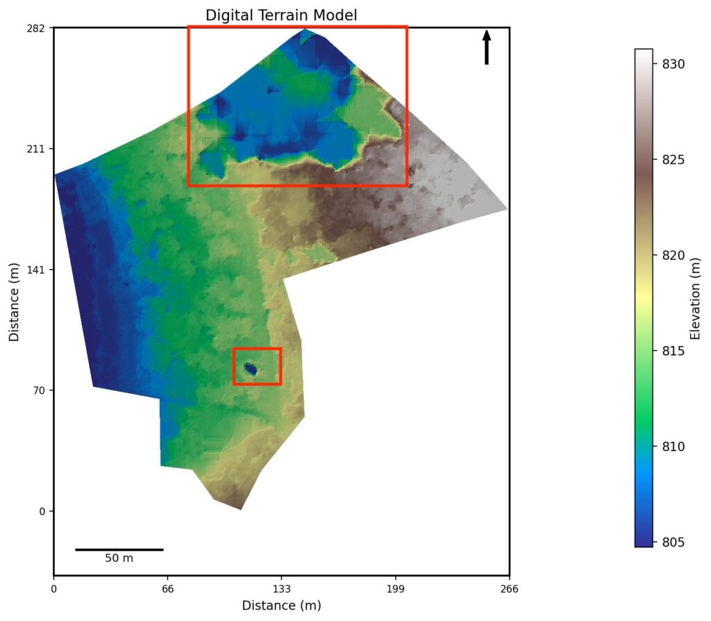
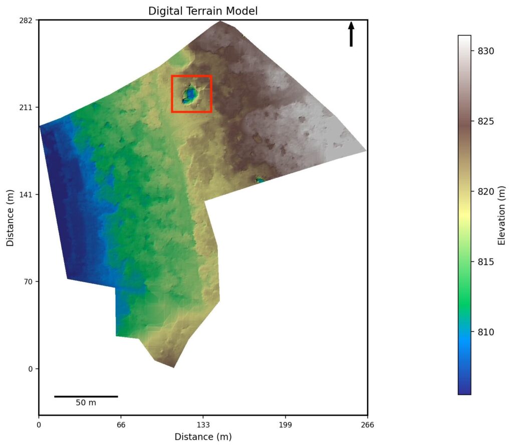
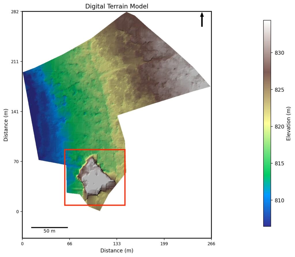
Digital Terrain Model (DTM) Analysis
Flight Altitudes:
150 ft
200 ft
400 ft
Observations:
Crater anomalies: Visible dips (altitude errors) in the DTM at certain flight altitudes.
Plateau anomalies: Artificial elevation rises in some sections.
These anomalies appeared “washed out” with noticeable boxy stitching patterns — more prominent at higher altitudes.
Pros and Cons at Different Altitudes
Altitude
Pros
Cons
400 ft
Fast survey; clear path demarcation
Higher sensitivity to tree canopy; washouts likely
200 ft
Best balance; minimum anomalies
Some loss of detail under dense canopy, but best off the lot
150 ft
Most terrain detail captured
Longer flight time; larger data volume; washouts very possible at tall tree areas
Processing Comparison
Using WebODM for photogrammetric processing:
GPS Accuracy: Non-RTK drone, GPS errors around 30 cm. With RTK, expected error is 5–15 cm.
Image Count:
400 ft: 1x baseline
200 ft: 4x more images
150 ft: 6x more images
Flight Duration:
400 ft: 13 minutes
200 ft: 16 minutes
150 ft: 25 minutes
Higher-resolution surveys require more images and longer processing time — a trade-off plantation managers must consider during drone survey planning.
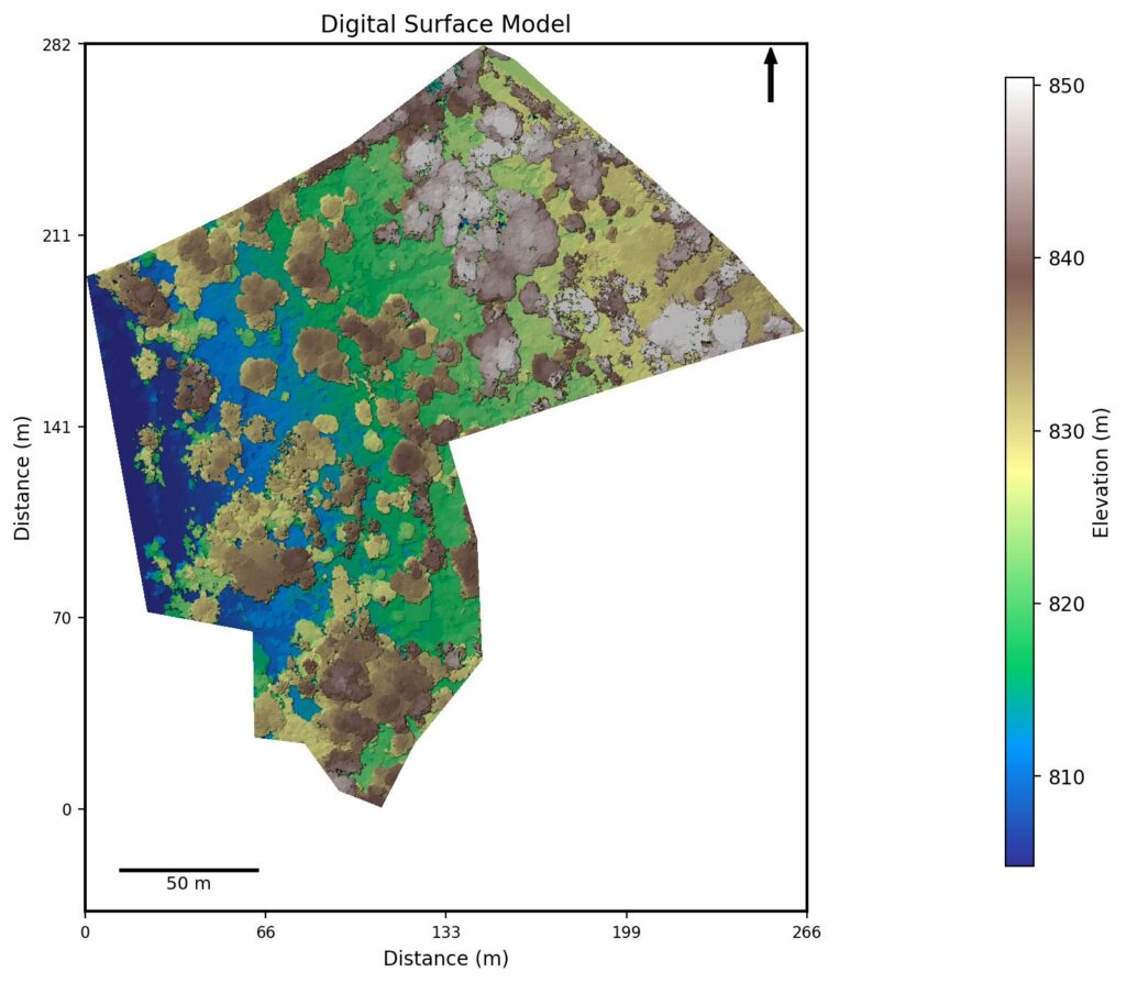
Digital Surface Model (DSM)
Unlike DTMs, the DSM (Digital Surface Model) maps the canopy and surface features without attempting to penetrate through.
Tree Height Estimation: Canopy top: 850 meters Ground from DTM: 825 meters → Tree height: 25 meters (about 80 feet)
Canopy Challenges: Flying too high above dense canopies (much greater than 120–130 ft above tallest trees) risks incomplete terrain data due to sunlight blockage and reduced triangulation resulting in plateau anomalies. Yet a minimum of 130 ft is recommended for preventing crater anomalies.
Thus, for coffee plantation drone surveys or dense plantation drone mapping, maintaining optimal flight height is critical.
ORthoMosaics - RGB and Multispectral imagery
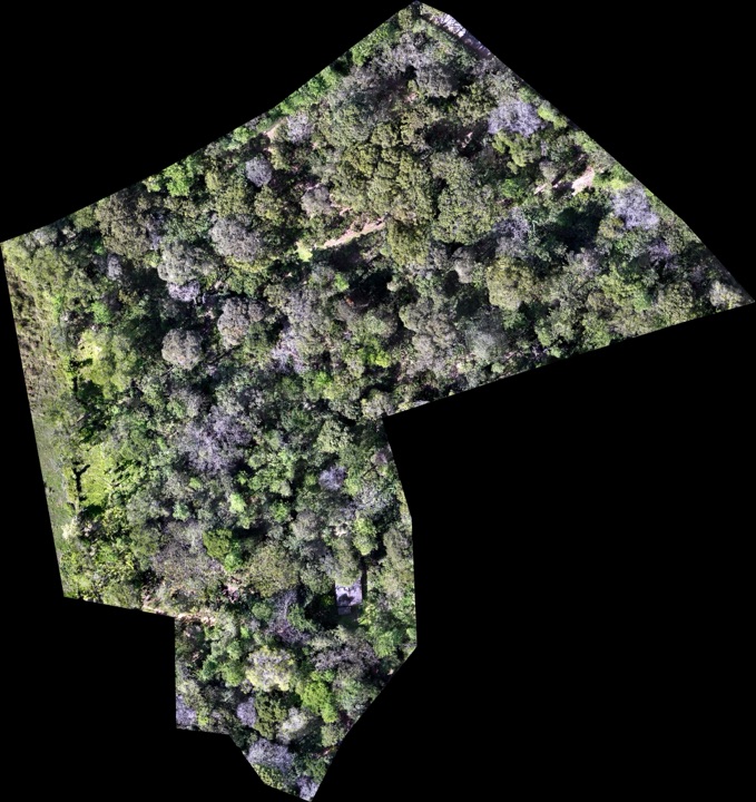
RGB Orthomosaics (standard color images) offer human-friendly high-resolution aerial views — akin to Google Earth but sharper. They allow manual inspection of land features, tree lines, and plantation boundaries.
Multispectral Orthomosaics, using NIR (Near Infrared) and Red Edge bands, help detect crop health, identifying pest or disease stress using vegetation indices like NDVI.
Green areas: Healthy crops
Yellow/red areas: Stressed or degraded vegetation
Future Thota is working towards delivering automated plant health analyses in future service offerings!
RGB Orthomosaic. Aerial view of trees and land.
Conclusion– Best Practices for Drone Surveys in Coffee Plantations
Based on our altitude study for drone surveys in Coorg coffee plantations, we recommend:
✅ Use Digital Terrain Models (DTMs) for area calculations, not just orthomosaics or DSMs. ✅ Fly around noon for maximum sunlight penetration through canopies. ✅ Maintain minimum 130 ft clearance above the tallest trees with 70% side and 80% front overlap. ✅ Use Terrain Follow mode (if available) to maintain consistent altitude over slopes. ✅ Plan fixed-altitude flights wisely: For 80 ft tall trees, set drone altitude between 210 ft–250 ft if terrain following is unavailable.
By following these guidelines, drone surveys for plantations can achieve highly accurate and actionable results — ensuring better management and decision-making for coffee estate owners and agricultural managers.