At Future Thota, we specialise in drone surveys for coffee plantations in Coorg, delivering precision-driven agricultural data insights. Compared to traditional methods, drones offer much more accurate land area surveys. Using highly precise GPS systems, we achieve mapping errors as low as a few centimetres.
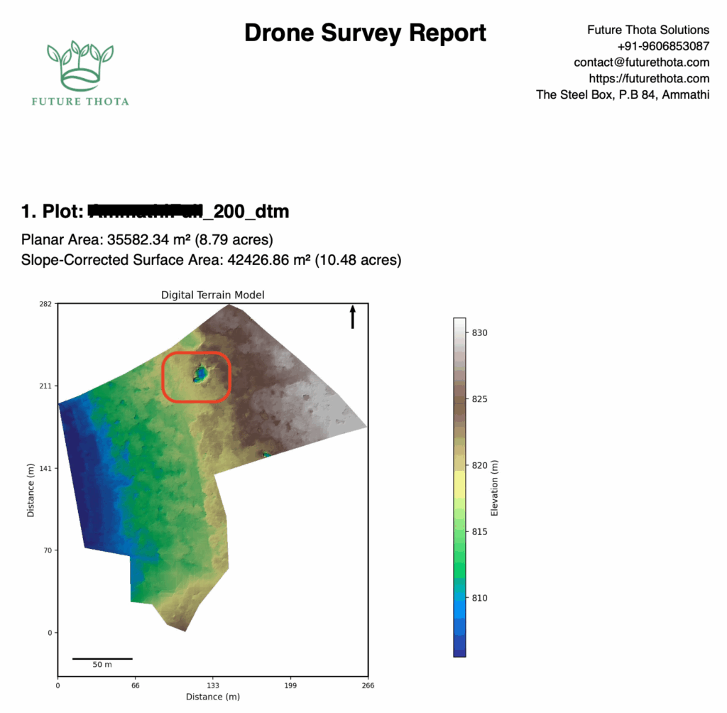
Through drone mapping, we generate Digital Terrain Models (DTMs) that represent the bare earth surface — removing trees, vegetation, and buildings. DTMs are critical for understanding land slope variations and calculating accurate surface area measurements.
In this study, we compare land survey data collected at different flight altitudes and recommend best practices for dense plantation environments.
Case Study Overview
This project focused on surveying a coffee plantation in Coorg, located in the Western Ghats of Southern India. We conducted multiple flights over the same property at different fixed altitudes — 150 ft, 200 ft, and 400 ft — to identify best practices.
Key parameters consistent across all flights:
- Front overlap: 80%
- Side overlap: 70%
- Fixed grid mission mode
Digital Terrain Model (DTM) Analysis
Observations by Altitude
| Altitude | Pros | Cons |
|---|---|---|
| 400 ft | Fast survey; clear path demarcation | Higher sensitivity to tree canopy; washouts likely |
| 200 ft | Best balance; minimum anomalies | Some loss of detail under dense canopy, but best overall |
| 150 ft | Most terrain detail captured | Longer flight time; larger data volume; washouts possible at tall tree areas |
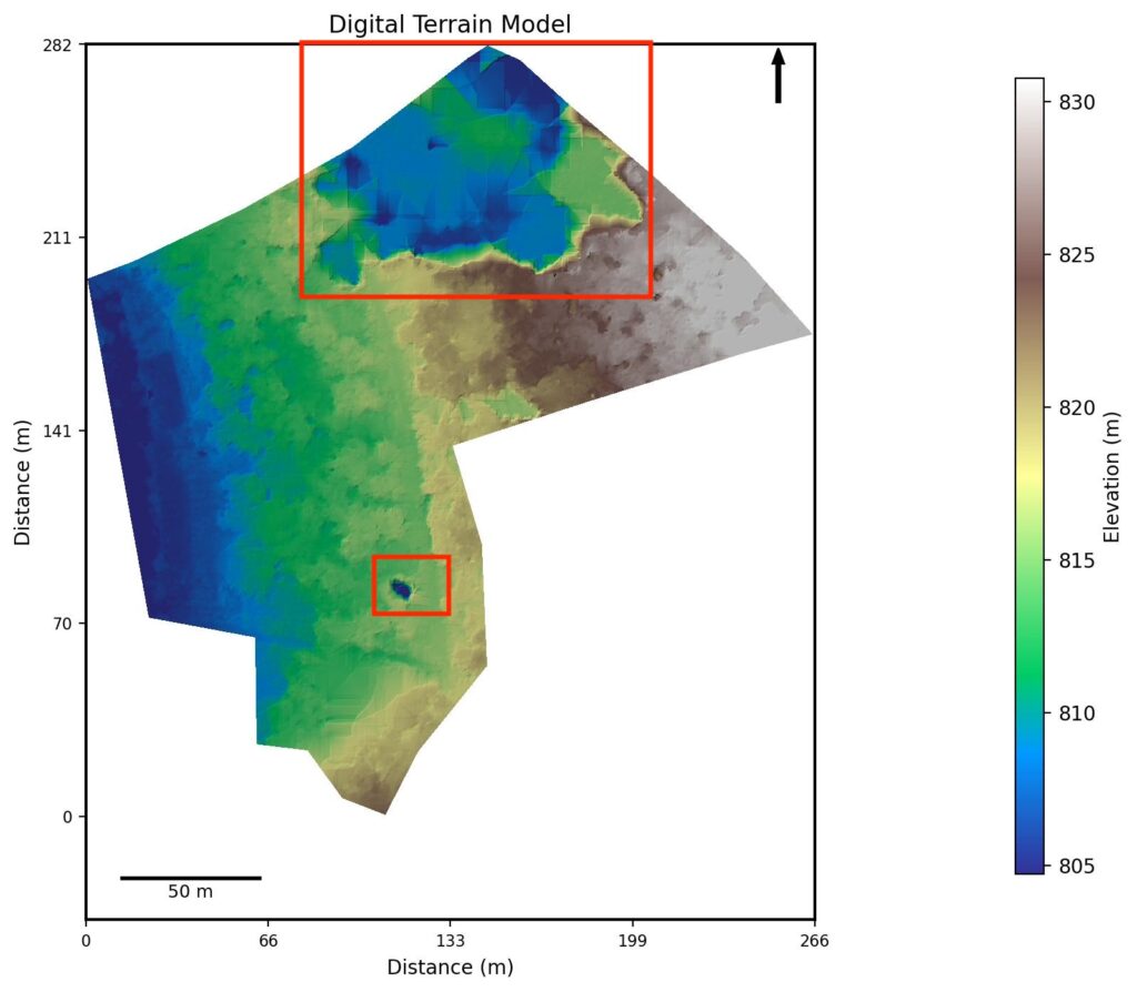
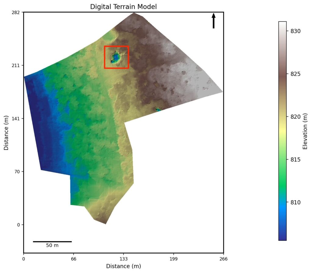
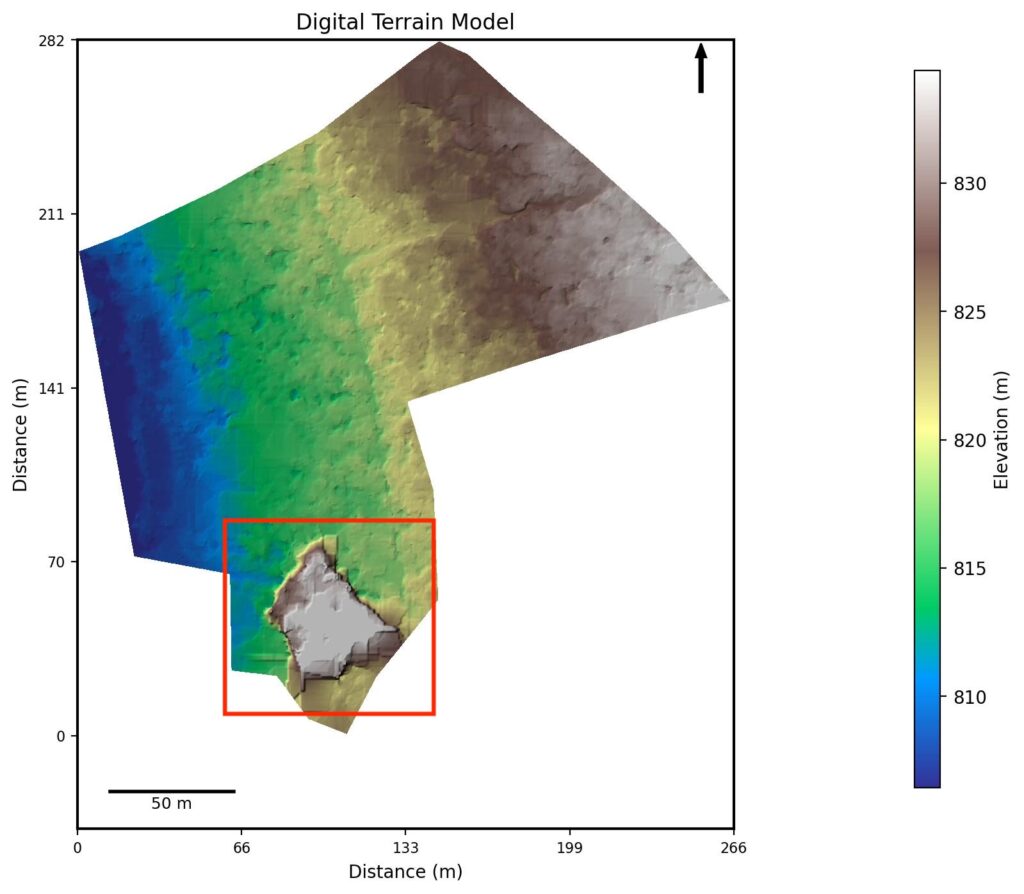
Two types of anomalies appeared in the DTM across altitudes:
- Crater anomalies — dips in the terrain model where the algorithm could not penetrate dense canopy
- Plateau anomalies — artificial elevation rises where image triangulation failed under heavy shade
Both anomaly types were more pronounced at higher altitudes and had a characteristic “washed out” boxy stitching pattern.
Processing Comparison
Using photogrammetry software for processing:
- GPS Accuracy: Standard GPS flights showed errors around 30 cm. With RTK or PPK corrections, expected error drops to 5–15 cm
- Image count at 200 ft: approximately 4× more images than at 400 ft
- Image count at 150 ft: approximately 6× more images than at 400 ft
- Flight duration: 400 ft = 13 min; 200 ft = 16 min; 150 ft = 25 min
Higher resolution surveys require more images and substantially longer processing time — a trade-off plantation managers must weigh against the required output quality.
Digital Surface Model (DSM)
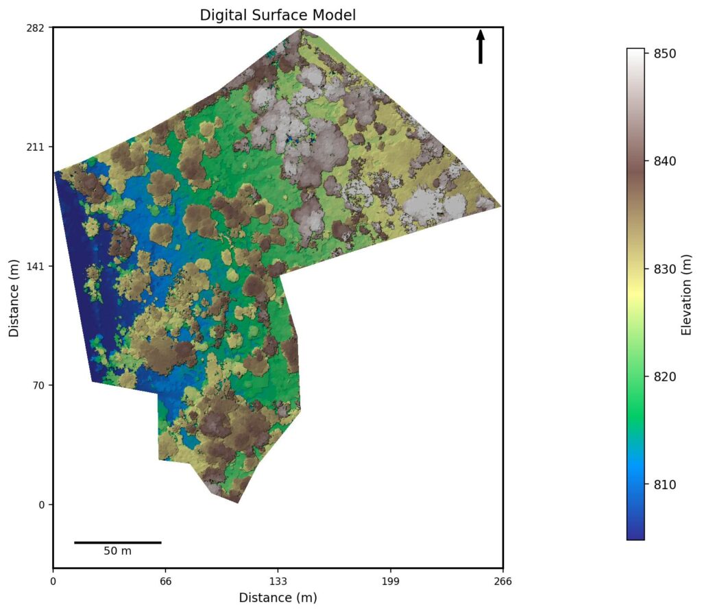
The DSM maps the canopy and surface features without attempting to penetrate through to ground level.
In this case study, tree height was estimated by subtracting the DTM ground elevation from the DSM canopy top elevation — yielding a tree height of approximately 25 metres (about 80 feet).
Canopy Challenges
Flying too far above dense canopies risks incomplete terrain data due to sunlight blockage and reduced image triangulation — resulting in plateau anomalies. Yet a minimum clearance of 130 ft above the tallest trees is recommended to prevent crater anomalies.
This creates an ideal flying window: at least 130 ft above the tallest trees, but not so high that canopy penetration fails. For 80-ft tall trees, this translates to a flight altitude of 210–250 ft above ground level.
Orthomosaics — RGB and Multispectral

RGB Orthomosaics (standard colour imagery) offer high-resolution aerial views comparable to Google Earth, but at 3–10 cm/pixel resolution. They allow manual inspection of land features, tree lines, and plantation boundaries.
Multispectral Orthomosaics, using near-infrared and red-edge bands, detect crop health by identifying pest or disease stress using vegetation indices like NDVI:
- Green zones — Healthy, photosynthetically active crops
- Yellow / red zones — Stressed or degraded vegetation
Future Thota is working towards delivering automated plant health analysis as part of its standard survey outputs.
Best Practices for Drone Surveys in Coffee Plantations
Based on this altitude study, we recommend:
- Use DTMs for area calculations, not just orthomosaics or DSMs — the DTM gives you slope-corrected true surface area
- Fly around noon for maximum sunlight penetration through the canopy
- Maintain minimum 130 ft clearance above the tallest trees, with 70% side and 80% front overlap
- Use Terrain Follow mode if available, to maintain consistent altitude over slopes
- Target 200 ft AGL for the best balance of resolution and reliability in dense coffee plantation environments
- For 80-ft tall trees without terrain follow, set drone altitude to 210–250 ft above ground level
By following these guidelines, drone surveys for plantations can achieve highly accurate and actionable results — supporting better management decisions for coffee estate owners and managers.
See our drone mapping checklist for the complete pre-flight preparation guide.