How PPK Enhances GPS Accuracy in Drone Mapping
Introduction
When it comes to drone mapping, accurate georeferencing is crucial for creating reliable orthomosaic maps and digital terrain models (DTMs). Two primary methods dominate the landscape: GPS-only positioning and Post-Processed Kinematic (PPK) corrections. While GPS-only mapping is simpler, PPK workflows provide enhanced accuracy that can be vital for precision surveying and analysis. RTK is also an option but is not necessary for drone mapping. The PPK workflow resolves some of the issues of RTK while still delivering comparable results.
In this article, we’ll break down the differences between PPK workflow and GPS-only geotagging, analyze a real-world case study, and discuss how each method impacts your mapping projects.
Understanding Accuracy in Drone Mapping
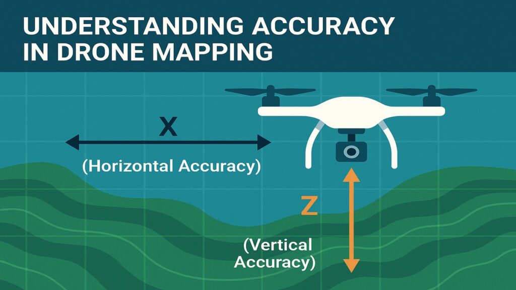
When creating orthomosaic maps, two types of accuracy are important:
1. Relative Accuracy
This refers to how well images are stitched together in relation to each other. In drone mapping, this includes:
X and Y (Horizontal Accuracy): How precise the images are when viewed from the top down.
Z (Vertical Accuracy): Critical for estimating DTMs and analyzing elevation changes.
2. Absolute Accuracy
Absolute accuracy is the degree to which the mapped area aligns with global coordinates. For GIS and legal boundary definitions, this alignment is crucial. This is where PPK shines compared to standard GPS.
RTK vs PPK: Why PPK Might Be Better for You
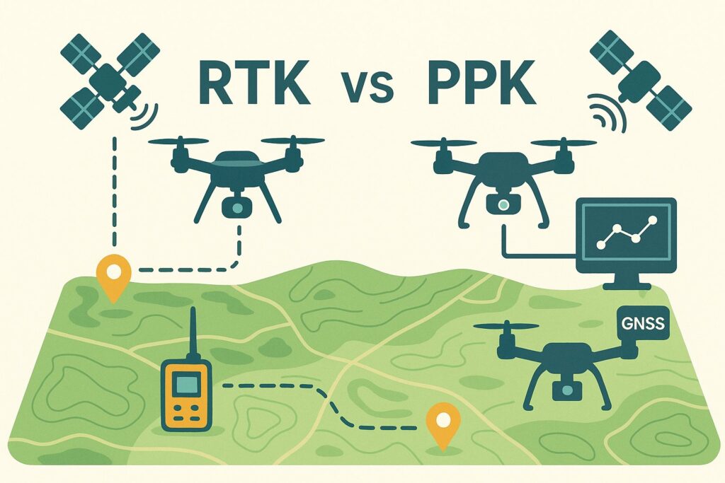
Real-Time Kinematic (RTK) corrections can be applied live during a drone flight. This can be done through:
A physical base station, or
An NTRIP service.
While NTRIP services remove the need for the expensive, large, and time-consuming physical base station workflows, they introduce their own challenges:
Inconsistent or unavailable mobile networks
Distance limitations from CORs stations (less than 15 km from flight site is necessary)
Service downtime or infrastructure issues
Expired subscriptions
Instead of relying on real-time corrections, PPK allows for post-processing of GPS data, reducing dependency on live connectivity and improving reliability
Case Study: Plantation Drone Mapping (20 Acres)

In a recent project, a 20-acre plantation was mapped using a drone equipped with RTK capability. However, due to connectivity issues, RTK mode could not be activated, and the drone collected GPS-only tags during flight. This prompted us to explore PPK for georeferencing the images.
The results were impressive. Using Emlid Studio for post-processing, we generated three datasets:
GPS Only — Raw images with standard GPS tags.
PPK Float — Corrections applied with data from a single CORS station located 30 km away.
PPK Fix — Corrections using a ‘virtual’ base station data simulated at the flight coordinates, achieving a 100% ‘Fix’ status.
Below is a comparison of the error metrics across the three datasets:
| Metric | GPS-Only | PPK Float | PPK Fix |
|---|---|---|---|
| X RMS Error (m) | 0.130 | 0.121 | 0.090 |
| Y RMS Error (m) | 0.130 | 0.106 | 0.091 |
| Z RMS Error (m) | 0.340 | 0.333 | 0.167 |
| Total RMS Error (m) | 0.330 | 0.345 | 0.201 |
| CE90 (Horizontal, m) | 0.290 (abs) | 0.297 (abs) | 0.186 (abs) |
| 0.495 (rel) | 0.413 (rel) | 0.168 (rel) | |
| LE90 (Vertical, m) | 0.634 (abs) | 0.632 (abs) | 0.319 (abs) |
| 0.718 (rel) | 0.608 (rel) | 0.289 (rel) |
Interpreting the Results
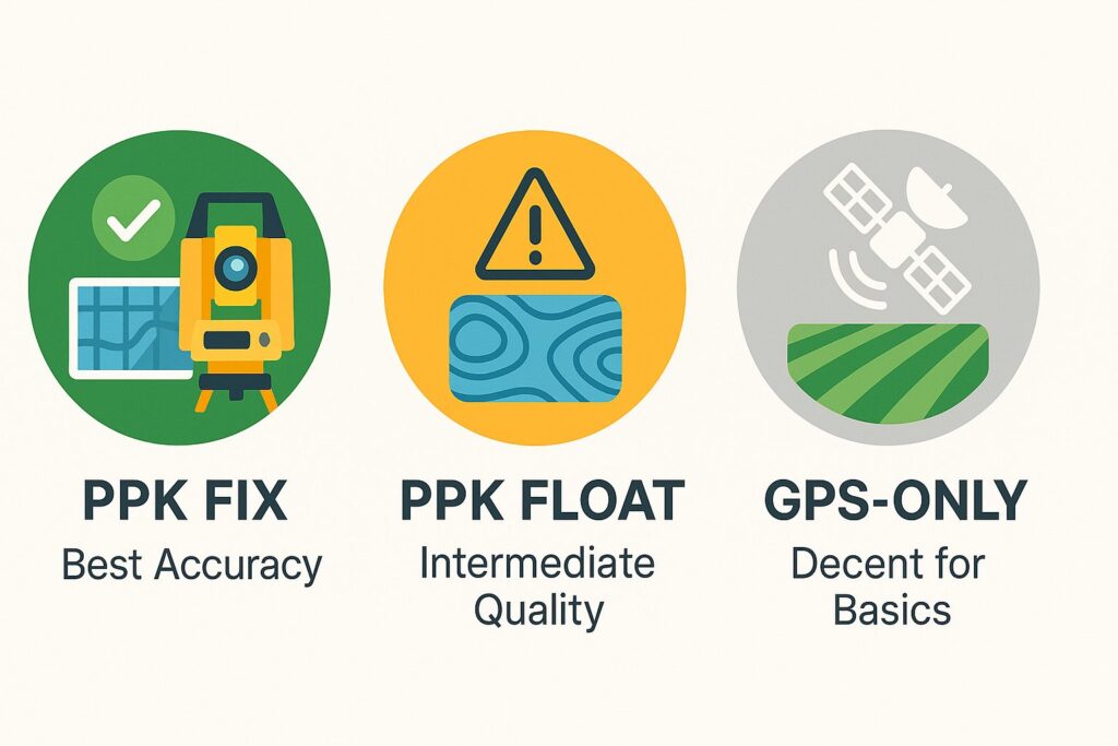
✅ PPK Fix (Best Accuracy)
Delivers sub-decimeter horizontal accuracy and improved vertical precision.
Ideal for surveying, contouring, and engineering use.
⚠️ PPK Float (Intermediate Quality)
Slightly worse than GPS-only in total RMS but still better for relative consistency.
Acceptable for medium-precision applications but not suitable for fine-detail analysis.
⚪ GPS-Only (Decent for Basics)
Delivers ~0.3 m RMS, surprisingly good for standard GPS.
Suitable for basic field mapping but not for high-precision tasks.
Understanding GPS Error Metrics
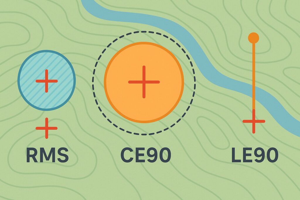
RMS (Root Mean Square Error): Measures average deviation from expected GPS positions.
CE90 (Circular Error 90%): Horizontal precision within which 90% of horizontal errors fall.
LE90 (Linear Error 90%): Height precision within which 90% of the vertical errors fall.
These metrics provide insight into both the precision and reliability of your drone mapping outputs.
Conclusion: When to Choose PPK Over GPS
If high accuracy is critical — such as for legal boundary mapping, contouring, or DTMs — PPK Fix is the superior choice. For quick field surveys where absolute accuracy is less crucial, and measurements are not needed, GPS-only can still be a reliable option. PPK Float falls somewhere in the middle but is less consistent than PPK Fix.