PPK Drone Mapping in India: Using CORS/VRS Data for High-Precision Results
Accurate geo-referencing is critical in drone-based plantation mapping and agri-intelligence. Traditional GPS positioning can have errors up to 30 feet, which isn’t suitable for precision agriculture or land development assessments. This is where PPK drone mapping in India offers a cost-effective and high-precision alternative, especially when using CORS or VRS data from the Survey of India.
While Real-Time Kinematic (RTK) systems require active network subscriptions and real-time corrections, Post-Processed Kinematic (PPK) systems allow you to correct GPS coordinates after the flight, achieving centimeter-level accuracy at a fraction of the RTK cost. In many use cases, including agriculture mapping and topographic surveys, PPK is sufficient and more economical.
Why PPK Is a Smart Choice in India
PPK doesn’t require a continuous internet connection or RTK subscription. Instead, it leverages raw drone GPS logs and precise base station corrections from the Survey of India (SOI). These corrections are available via:
CORS Data – From a known SOI CORs base station nearby
VRS Data – Simulated corrections at your drone’s coordinates
For large-scale or rural operations—such as those Future Thota handles across South India—PPK provides scalable accuracy without real-time infrastructure.
Step-by-Step: How to Perform PPK Drone Mapping in India
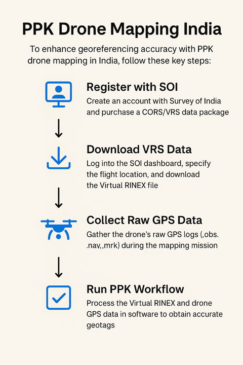
Step 1: Register with Survey of India
Go to the Survey of India website and create an account.
Purchase a correction data subscription (e.g., RDS6, RDS20, or RDS50 depending on your mapping volume).
These packages allow you to download CORs/VRS RINEX data, essential for PPK correction.
Step 2: Download VRS or CORS Data from SOI
Once logged into your regional SOI dashboard (e.g., Region 2 for mid and southern India – check the locations on SOI website):
Navigate to Post Processing > RINEX Data.
You’ll have two options:
Option 1: Download CORS Data
Choose a base station manually (within 15 km of your flight location for best results).
Option 2: Download VRS Data (Recommended)
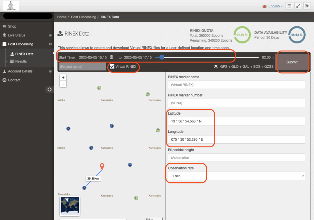
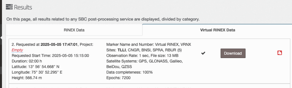
- Enter your drone flight’s latitude and longitude.
Set the time window to span at least 15 minutes before and after the drone flight.
Keep the observation rate at 1 second.
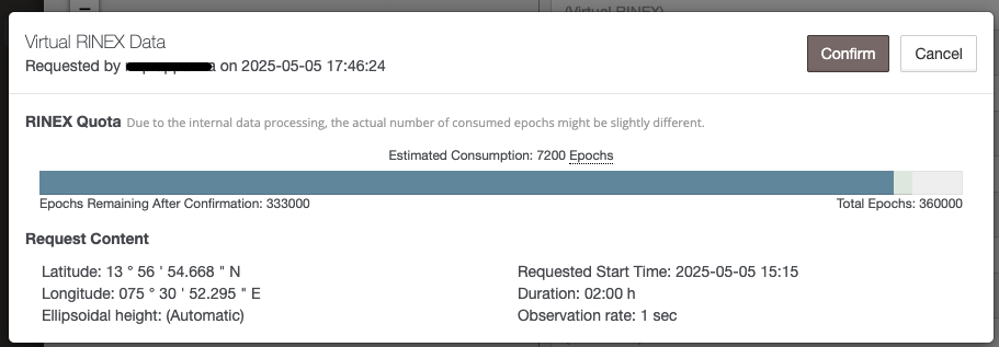
The system calculates your usage quota based on the number of observation epochs. The downloaded ZIP includes several files:
.25o– Observations (used as base).25n– Navigation (best for base station correction)
Other file types like .25f, .25l, .25q are optional or less accurate.
Step 3: PPK Workflow Using Emlid Studio
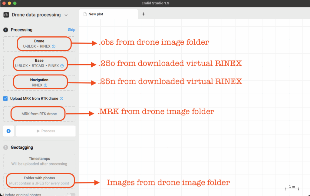
To process the corrected GPS data:
From your drone:
These files are typically found in the drone mission images folder in DJI Enterprise drones.
.obsfile – Raw GPS logs.mrkfile – Image timestampsRaw images – To be geo-tagged with corrected coordinates
From VRS or CORS ZIP:
.25o– Base observation file.25n– Base navigation file
In Emlid Studio:
Select PPK Processing.
Load the drone
.obsand.mrkfiles.Load the base
.25oand.25nfiles.Process to generate
.pos(corrected timestamps).Apply these corrections to your images before uploading to your photogrammetry software.
Step 4: Interpret the Results
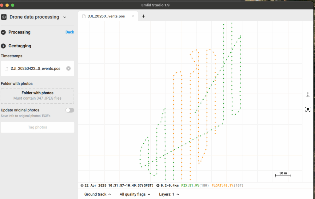
In Emlid Studio or similar tools, corrected positions are classified as:
Single – No correction applied (least accurate)
Float – Some correction (moderate accuracy)
Fix – Full correction (best accuracy; sub-meter or centimeter level)
A high Fix percentage across image timestamps ensures the quality and reliability of your output orthomosaics and 3D models.
How Future Thota Leverages PPK for Agri-Intelligence
At Future Thota, we routinely deploy PPK workflows using CORS/VRS data to deliver centimeter-grade mapping for plantations, farm assessments, and irrigation planning. Especially in rural or semi-urban zones where RTK coverage is sparse, our drone teams rely on efficient post-processing to achieve actionable insights.
By integrating VRS correction into our mapping pipeline, we ensure our datasets are not only accurate but repeatable—key for longitudinal crop analysis and investment-grade land documentation.
Final Thoughts
PPK drone mapping in India is a practical and scalable solution for professionals needing precise location data without heavy investment in real-time correction systems. With SOI’s growing CORS/VRS infrastructure, it’s easier than ever to run high-accuracy mapping projects with minimal overhead.
For agriculture, land development, or environmental monitoring, this workflow balances affordability and precision—exactly the kind of edge Future Thota delivers to its clients.